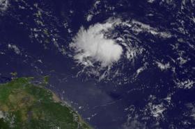
NOAA's GOES-East Satellite spotted potential Tropical Depression 9 organizing east of the Lesser Antilles.
At 10:45 a.m. EDT (1445 UTC) on Aug. 13 NOAA's GOES-East satellite captured a visible image of potential Tropical Depression 9. The satellite imagery showed the circulation of the low pressure area was becoming better defined and that a cluster of strong convection has formed west of the center.
NOAA manages the GOES series of satellites, and NASA uses the satellite data to create images and animations. The image was created by the NASA/NOAA GOES Project at NASA's Goddard Space Flight Center in Greenbelt, Maryland.
The potential Tropical Depression Nine (TD9) formed around 11 p.m. EDT on Aug. 17 about 365 miles east of the Barbados and 465 miles (750 km) east of St. Lucia.
The National Hurricane Center (NHC) issued a Tropical Storm Warning for Martinique, St. Lucia, Barbados, St. Vincent and the Grenadines. A Tropical Storm Watch is in effect for Dominica. Tropical storm conditions are expected to first reach the Lesser Antilles within the warning area by early Friday, Aug. 18.
Read more at NASA / Goddard Space Flight Center
Image: At 10:45 a.m. EDT (1445 UTC) on Aug. 13, 2017, NOAA's GOES-East satellite captured a visible image of Atlantic Ocean potential Tropical Depression 9 approaching the Lesser Antilles.
Credits: NASA / NOAA GOES Project


