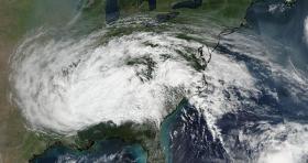
Satellite imagery showed the large extent of the remnant clouds and rains from what was Hurricane Irma. Those remnants were blanketing about a quarter of the continental U.S. over the Ohio and Tennessee Valleys and east to the Mid-Atlantic States.
Satellite imagery showed the large extent of the remnant clouds and rains from what was Hurricane Irma. Those remnants were blanketing about a quarter of the continental U.S. over the Ohio and Tennessee Valleys and east to the Mid-Atlantic States.
The Visible Infrared Imaging Radiometer Suite (VIIRS) instrument aboard NASA-NOAA’s Suomi NPP satellite took a visible light picture of Irma’s remnant clouds on Sept. 13 at 4 p.m. EDT (2000 UTC). The image showed the large extent of Irma’s remnant clouds.
NOAA’s National Weather Service Weather Prediction Center (WPC) in College Park, Maryland said that “Post-tropical cyclone Irma will continue to weaken and lift northwestward through Wednesday. Moderate to locally heavy rain in the Mid-South and Southeast will lift into the Ohio Valley and Middle Atlantic by Wednesday. Some of the heavier rainfall may produce flash flooding. Isolated thunderstorms will also be possible in the middle Atlantic.”
Read more at NASA/Goddard Space Flight Center
Image: NASA-NOAA's Suomi NPP satellite captured this image of Irma's remnant clouds on Sept. 13 at 4 p.m. EDT (2000 UTC). The clouds extend from Missouri to the Mid-Atlantic states. (Credit: NOAA/NASA Goddard Rapid Response Team)


