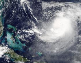
NASA’s Terra satellite is one of many satellites keeping a close eye on Hurricane Jose and saw the storm between the Bahamas and Bermuda.
NASA’s Terra satellite is one of many satellites keeping a close eye on Hurricane Jose and saw the storm between the Bahamas and Bermuda.
On Sept. 12 at 1:35 p.m. EDT (15:35 UTC) the Moderate Resolution Imaging Spectroradiometer (MODIS) instrument aboard NASA’s Terra satellite captured a visible image of Hurricane Jose. In the image, Jose appeared somewhat elongated as a result of vertical wind shear affecting the storm.
At 5 a.m. AST/EDT (0900 UTC), the center of Hurricane Jose was located near 26.1 degrees north latitude and 66.0 degrees west longitude. That’s about 505 miles (810 Km) east-northeast of the southeastern Bahamas and 435 miles (700 km) south of Bermuda. Jose was moving toward the southeast near 8 mph (13 km/h), but it is expected to make a slow clockwise loop during the next 36 to 48 hours, moving west-northwestward by late Thursday, Sept. 14. Maximum sustained winds are near 75 mph (120 kph) with higher gusts. Little change in strength is forecast during the next 48 hours. The estimated minimum central pressure is 985 millibars.
Read more at NASA/Goddard Space Flight Center
Image: On Sept. 12 at 1:35 p.m. EDT (15:35 UTC) the MODIS instrument aboard NASA's Terra satellite captured this visible image of Hurricane Jose northeast of the Bahamas in the Atlantic Ocean. (Credit: NASA Goddard MODIS Rapid Response Team)


