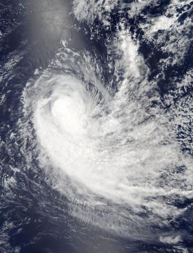
NASA's Aqua satellite passed over Tropical Cyclone Irving and found wind shear was stretching the storm out.
NASA's Aqua satellite passed over Tropical Cyclone Irving and found wind shear was stretching the storm out.
The Moderate Resolution Imaging Spectroradiometer or MODIS instrument that flies aboard Aqua provided a visible-light image of the depression on Jan. 2, 2018. The image showed persistent development thunderstorms around the center of circulation that were being sheared slightly to the south.
At 10 a.m. EST (1500 UTC) on Jan. 9, 2018, Tropical Cyclone Irving was located approximately 861 nautical miles east-southeast of Port Louis, Mauritius, near 23.2 degrees south latitude and 71.9 degrees east longitude. Irving was moving to the west-southwest at 18 knots (20.7 mph/33.3 kph) and had maximum sustained winds near 70 knots (80 mph/129.6 kph).
Read more at NASA/Goddard Space Flight Center
Image: NASA's Aqua satellite captured a visible-light image of Tropical Cyclone Irving on Jan. 9, 2018 at 3:45 a.m. EST (0845 UTC). The image showed the storm to be somewhat elongated. (Credit: NASA Rapid Response Team)


