A developing area of tropical low pressure designated System 96W was affecting the central Philippines when NASA-NOAA’s Suomi NPP satellite passed overhead.
A developing area of tropical low pressure designated System 96W was affecting the central Philippines when NASA-NOAA’s Suomi NPP satellite passed overhead.
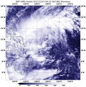
On Dec. 13 at 0412 UTC (Dec. 12 at 11:12 p.m. EST) NASA-NOAA's Suomi NPP satellite provided a visible image of System 96W as its western quadrant moved over the east central Philippines. The Visible Infrared Imaging Radiometer Suite (VIIRS) instrument aboard NASA-NOAA's Suomi NPP satellite showed the center of the storm over the Philippine Sea. The low pressure area appeared elongated from southwest to northeast.
Animated multispectral imagery showed several unorganized convective areas to the north and one band of thunderstorms wrapping into the low level circulation center. Another satellite image showed that storms were building up to the north of the center.
The Joint Typhoon Warning Center (JTWC) noted that “available data does not justify issuance of numbered tropical cyclone warnings at this time.” However, System 96W has a high chance to develop into a tropical depression over the next day.
Read more at NASA/Goddard Space Flight Center
Image: On Dec. 13 at 0412 UTC (Dec. 12 at 11:12 p.m. EST) NASA-NOAA's Suomi NPP satellite provided a visible image of System 96W as its western quadrant moved over the east central Philippines. The low pressure area appeared elongated from southwest to northeast. (Credit: NASA/NOAA/NRL)


