Satellites are keeping an eye on the U.S. and NOAA’s GOES East satellite showed two storm systems for pre-Thanksgiving travelers on Wednesday, Nov. 22, 2017. One system was exiting the northeastern U.S. while the other was affecting the Pacific Northwest.
Satellites are keeping an eye on the U.S. and NOAA’s GOES East satellite showed two storm systems for pre-Thanksgiving travelers on Wednesday, Nov. 22, 2017. One system was exiting the northeastern U.S. while the other was affecting the Pacific Northwest.
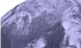
On Nov. 22 at 10:15 a.m. EST (1515 UTC) NOAA's GOES-East satellite captured this visible image of the U.S. showing storm systems on the East and West coasts for Thanksgiving travelers. In the northeastern U.S. clouds associated with a cold front were covering the New England states in the image. Clouds associated with a system in the Pacific Northwest were seen over Washington State, Oregon, Idaho, Montana and Colorado.
Pre-Thanksgiving travelers in the northern Plains and Upper Great Lakes will experience arctic air that is expected to bring periods of snow, blustery winds and cold wind chills. The National Weather Service said that light snow is also possible in New England and the Ohio Valley.
Read more at NASA/Goddard Space Flight Center
Image: On Nov. 22 at 10:15 a.m. EST (1515 UTC) NOAA's GOES-East satellite captured this visible image of the US showing storm systems on the East and West coasts for Thanksgiving travelers. (Credit: NOAA/UWM-CIMSS)


