Now an extra-tropical cyclone over northern Japan, Lan was a typhoon when it made landfall just south of Tokyo over the weekend of Oct. 21 and 22. NASA's Aqua satellite and NASA-NOAA's Suomi NPP satellite provided imagery of the extra-tropical cyclone.
Now an extra-tropical cyclone over northern Japan, Lan was a typhoon when it made landfall just south of Tokyo over the weekend of Oct. 21 and 22. NASA's Aqua satellite and NASA-NOAA's Suomi NPP satellite provided imagery of the extra-tropical cyclone.
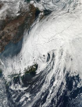
On Oct. 23 at 03:42 UTC (Oct. 22 at 11:42 p.m. EDT) NASA-NOAA's Suomi NPP satellite provided this visible image of Post-tropical cyclone Lan over Hokkaido, Japan. Hokkaido is the northernmost of Japan’s main islands. The image showed the center near Hokkaido while clouds from the western side of the storm extended into the Sea of Japan.
The Atmospheric Infrared Sounder aboard NASA's Aqua satellite captured an infrared image of Lan on Oct. 23 at 03:53 UTC (Oct. 22 at 11:53 p.m. EDT). Infrared data provides cloud top temperatures and the coldest cloud tops and strongest storms were in eastern Hokkaido.
Read more at NASA/Goddard Space Flight Center
Image: On Oct. 23 at 03:42 UTC (Oct. 22 at 11:42 p.m. EDT) NASA-NOAA's Suomi NPP satellite provided this visible image of Post-tropical cyclone Lan over Hokkaido, Japan.
Image Credits: NOAA/NASA Goddard Rapid Response Team


