Tropical Depression 15E is being affected by vertical wind shear on NASA satellite imagery and appears almost shapeless.
Tropical Depression 15E is being affected by vertical wind shear on NASA satellite imagery and appears almost shapeless.
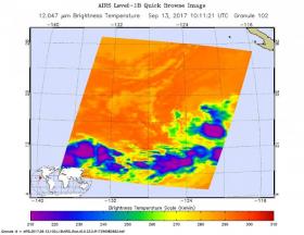
The AIRS instrument aboard NASA’s Aqua satellite captured infrared temperature data on Tropical Depression 15E’s clouds on Sept. 13 at 6:11 a.m. EDT (1011 UTC). At the time, the storm appeared to have some strong thunderstorms in two areas around the center. The National Hurricane Center noted that “The cloud pattern has not become any better organized since yesterday and consists of a low-level center in between two shapeless blobs of deep convection.”
At 11 a.m. EDT (8 a.m. PDT/1500 UTC) on Sept. 13, the center of Tropical Depression Fifteen-E was located near 14.9 degrees north latitude and 120.6 degrees west longitude, about 890 miles (1,435 km) southwest of the southern tip of Baja California. The depression is moving toward the west near 9 mph (15 kph) and the National Hurricane Center said this general motion is expected to continue during the next couple of days. The estimated minimum central pressure is 1005 millibars.
Maximum sustained winds remain near 35 mph (55 kph) with higher gusts. No significant change in strength is expected today, but the depression could become a tropical storm in day or two.
Read more at NASA/Goddard Space Flight Center
Image: The AIRS instrument aboard NASA's Aqua satellite captured this image of Tropical Depression 15E on Sept. 13 at 6:11 a.m. EDT (1011 UTC), and purple indicates the strongest storms. (Credit: NASA JPL, Ed Olsen)


