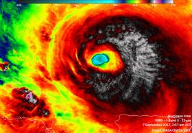
Satellite imagery from NASA's Aqua satellite and NASA-NOAA's Suomi NPP satellite have provided different data on the still Category 5 Hurricane Irma as it headed for the Turks and Caicos Islands.
Satellite imagery from NASA's Aqua satellite and NASA-NOAA's Suomi NPP satellite have provided different data on the still Category 5 Hurricane Irma as it headed for the Turks and Caicos Islands.
NASA's Aqua Satellite Imagery
On Sept. 6 at 1:45 p.m. EDT (1745 UTC) the Moderate Resolution Imaging Spectroradiometer or MODIS instrument aboard NASA's Aqua satellite captured a visible-light image of Hurricane Irma over the Leeward Islands and Puerto Rico. The image revealed a clear eye with powerful bands of thunderstorms circling the eye.
On Sept. 7, when Aqua passed over Irma again, another instrument aboard Aqua gathered temperature data on the storm's clouds, which tell forecasters where the strongest parts of the hurricane is located. The colder the cloud tops, the higher the storm, and the stronger it is.
Read more at NASA / Goddard Space Flight Center
Image: At 2:57 a.m. AST/EDT on Sept. 7, Infrared imagery from Suomi NPP revealed cloud top temperatures as cold as (white) 190 kelvin (minus 83.1 degrees Celsius/minus 117.7 degrees Fahrenheit) from Irma's northern quadrant, stretching through the eastern side to the south of the eye.
Credits: NOAA / NASA / UWM-CIMSS, William Straka III


