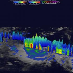
The Global Precipitation Measurement mission or GPM core satellite has been providing rainfall rates and cloud heights in tropical cyclones, and recently found towering thunderstorms that indicated strengthening in Tropical Storm Jose. Those "hot towers" were an indication the storm was strengthening and it later became a hurricane.
The Global Precipitation Measurement mission or GPM core satellite has been providing rainfall rates and cloud heights in tropical cyclones, and recently found towering thunderstorms that indicated strengthening in Tropical Storm Jose. Those "hot towers" were an indication the storm was strengthening and it later became a hurricane.
The GPM core observatory satellite passed above the intensifying tropical cyclone on Sept. 6, 2017 at 12:45 a.m. AST/EDT (0435 UTC). GPM is a joint mission between NASA and the Japan Aerospace Exploration Agency, JAXA.
Data collected by GPM's Microwave Imager (GMI) at that time showed that weak bands of rain were starting to develop around Jose's center of circulation. GPM's Dual-Frequency Precipitation Radar (DPR) data swath revealed the location of heavy rain in a feeder band on Jose's western side. DPR found that rain in this area was falling at a rate of over 5.3 inches (134 mm) per hour.
Continue reading at NASA / Goddard Space Flight Center
Image: On Sept. 6, the GPM core satellite passed over Tropical Storm Jose and found that rain on the western side of the storm was falling at a rate of over 5.3 inches (134 mm) per hour. GPM revealed a few "hot towers" in feeder band of thunderstorms were reaching to heights of almost 9.9 miles (16 km). Credits: NASA / JAXA, Hal Pierce


