Just after Tropical Storm Pakhar made landfall in southeastern China and NASA-NOAA's Suomi NPP satellite captured an image of the storm.
Just after Tropical Storm Pakhar made landfall in southeastern China and NASA-NOAA's Suomi NPP satellite captured an image of the storm.
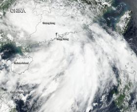
On Aug. 26,the Visible Infrared Imaging Radiometer Suite (VIIRS) instrument aboard NASA-NOAA's Suomi NPP satellite captured a visible image of Tropical Storm Pakhar over southeastern China. The image showed the center of circulation over southern Guangdong Province, and the bulk of clouds on the eastern side of the circulation extending into the South China Sea.
Continue reading at NASA
Image: On Aug. 26 NASA-NOAA's Suomi NPP satellite captured a visible image of Tropical Storm Pakhar over southeastern China.
Credits: NOAA / NASA


