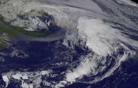
NASA’s Aqua satellite and NOAA's GOES-East satellite provided an infrared and visible look at Atlantic Hurricane Gert. Both images showed the storm was being affected by wind shear and had become elongated.
NASA’s Aqua satellite and NOAA's GOES-East satellite provided an infrared and visible look at Atlantic Hurricane Gert. Both images showed the storm was being affected by wind shear and had become elongated.
The Atmospheric Infrared Sounder or AIRS instrument that flies aboard NASA's Aqua satellite analyzed Gert in infrared light on Aug. 17 at 8:45 a.m. EDT (1145 UTC). AIRS data showed Gert coldest cloud top temperatures exceeded minus 63 degrees Fahrenheit (minus 53 degrees Celsius) and were being pushed northeast of the center. Storms with temperatures that cold are high in the troposphere and NASA research has shown they have the ability to generate heavy rain.
On Aug. 17 at 8:45 a.m. EDT (1145 UTC) NOAA's GOES-East satellite provided a visible image of Gert. The National Hurricane Center said that the convective structure of Gert had rapidly deteriorated during the morning hours due to very cold sea surface temperatures and increasing strong vertical wind shear. The GOES-East image showed that Gert still had some strong thunderstorm development in the northeast quadrant, but it appeared elongated from south-southwest to north-northeast.
Read more at NASA/Goddard Space Flight Center
Image: This GOES-East satellite visible-light image of Tropical Storm Gert taken at 8:45 a.m. EDT (1145 UTC) on Aug. 17 far to the east of Nova Scotia, Canada. (Credit: NASA/NOAA GOES Project)


