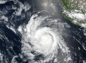
When the NASA-NOAA Suomi NPP satellite passed over the Eastern Pacific Ocean on July 25 it captured a visible close-up of Hurricane Hilary.
The Visible Infrared Imaging Radiometer Suite (VIIRS) instrument aboard the NASA-NOAA Suomi NPP satellite captured a visible light image of Hilaryon July 25 at 5:54 p.m. EDT (2154 UTC). The Suomi NPP image showed that Hilary appeared somewhat asymmetric.
The National Hurricane Center (NHC) noted an eye feature in the northwestern portion of the central dense overcast, suggestive of some northwesterly shear.
On July 26, NHC forecaster Blake said “The central dense overcast has become more symmetric, although convection is still preferentially forming in the eastern eyewall. Any eye feature, however, is somewhat less distinct than a few hours ago, and the latest microwave passes are again showing an open eyewall on the west side.”
Hilary remains a compact hurricane. Hurricane-force winds extend outward up to 15 miles (30 km) from the center and tropical-storm-force winds extend outward up to 90 miles (150 km). Of the three Eastern Pacific Ocean tropical cyclones: Greg, Irwin and Hilary, Hilary is closest to land, but it’s not close enough for coastal watches or warnings.
Continue reading at National Aeronautics and Space Administration (NASA)
Image: The NASA-NOAA Suomi NPP satellite captured a visible light image of Hurricane Hilary on July 25 at 5:54 p.m. EDT (2154 UTC) in the Eastern Pacific Ocean, far south-southwest of the southern tip of Baja California, Mexico.
Credits: NOAA / NASA Goddard Rapid Response Team


