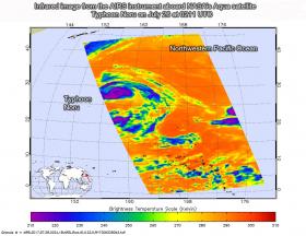
NASA's Aqua satellite provided a near-infrared look at Typhoon Noru as it continued its western track at sea, far to the southeast of Japan.
Near-infrared satellite imagery from the Atmospheric Infrared Sounder or AIRS instrument that flies aboard NASA's Aqua satellite taken on July 26 at 0211 UTC (July 25 at 10:11 p.m. EDT) showed provided a look at the temperatures of Noru’s clouds. That data was false colored and made into an image at NASA's Jet Propulsion Laboratory in Pasadena, California to highlight cloud top temperatures.
In infrared imagery, the coldest cloud tops indicate towering thunderstorms high into the troposphere. The colder the clouds, the stronger the storms. AIRS data showed a thick band of cloud tops around the center of circulation were as cold as or colder than minus 63 degrees Fahrenheit or minus 53 degrees Celsius. Cloud top temperatures that cold have been shown to generate heavy rainfall.
Continue reading at National Aeronautics and Space Administration (NASA)
Image: This infrared image of Typhoon Noru was taken from the AIRS instrument aboard NASA’s Aqua satellite on July 26 at 0211 UTC (July 25 at 10:11 p.m. EDT). The purple areas indicate the strongest storms with coldest cloud top temperatures.
Credits: NASA JPL, Ed Olsen


