NASA satellite imagery revealed that Tropical Depression 4 appears to be losing its punch, and the National Hurricane Center expects the storm to weaken.
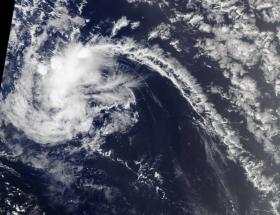
On July 7, 2017, at 11:30 a.m. EDT (1530 UTC), the Moderate Resolution Imaging Spectroradiometer, or MODIS, instrument aboard NASA's Terra satellite captured a visible image of Tropical Depression 4 as it continued moving through the north Central Atlantic Ocean. The image showed that the depression consisting of a possible circulation center embedded within a very small area of intermittent convection. The MODIS image does not show much organization.
NASA Sees Weakening of Tropical Depression 4
NASA satellite imagery revealed that Tropical Depression 4 appears to be losing its punch, and the National Hurricane Center expects the storm to weaken.
On July 7, 2017, at 11:30 a.m. EDT (1530 UTC), the Moderate Resolution Imaging Spectroradiometer, or MODIS, instrument aboard NASA's Terra satellite captured a visible image of Tropical Depression 4 as it continued moving through the north Central Atlantic Ocean. The image showed that the depression consisting of a possible circulation center embedded within a very small area of intermittent convection. The MODIS image does not show much organization.
The National Hurricane Center, or NHC, noted that the area of convection (rising air that forms the thunderstorms that make up a tropical cyclone) have been gradually decreasing since July 6.
Continue reading at National Aeronautics and Space Administration
Image: On July 7, 2017, at 11:30 a.m. EDT (1530 UTC), the MODIS instrument aboard NASA's Terra satellite captured this visible image of Tropical Depression 4 moving through the north central Atlantic Ocean. (Credits: NASA Goddard MODIS Rapid Response Team)


