Now a tropical storm, Hurricane Dora has been skirting southwestern Mexico’s coast since it formed and has transported tropical moisture onshore that has produced some heavy rain showers. The Global Precipitation Measurement mission or GPM core satellite has analyzed those rainfall rates.
Now a tropical storm, Hurricane Dora has been skirting southwestern Mexico’s coast since it formed and has transported tropical moisture onshore that has produced some heavy rain showers. The Global Precipitation Measurement mission or GPM core satellite has analyzed those rainfall rates.
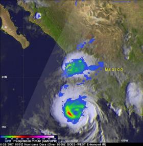
The GPM core observatory satellite flew over Mexico's Pacific Ocean Coast on June 26, 2017 at 0601Z (2:01 a.m. EDT). At that time Dora was moving toward the west-northwest parallel to Mexico's coastline and had just been upgraded to a hurricane. GPM's Microwave Imager (GMI) showed that rain was falling at a rate of over 2 inches (50.8 mm) per hour southwest of Dora's eye.
GPM's Dual-Frequency Precipitation Radar (DPR) swath covered an area west and north of hurricane Dora. GPM's Precipitation Radar (DPR) scanned intense storms located over Mexico's coast north of the hurricane’s center and found rainfall occurring there at a rate of 1.4 inches (35 mm) per hour. Heaviest rainfall occurred at a rate of over 2.4 inches (60.5 mm) per hour in Dora’s southwestern quadrant.
At NASA’s Goddard Space Flight Center in Greenbelt, Maryland where the rainfall analysis was conducted, GPM data was used to also create at 3-D look at the hurricane. The GPM 3-D scan showed that a few of these thunderstorms had cloud tops reaching altitudes higher than 9.9 miles (15.9 km). Downpours in these storms were returning radar reflectivity values greater than 55dBZ to the satellite. GPM is a joint mission between NASA and the Japanese space agency JAXA.
Read more at NASA/Goddard Space Flight Center
Image: On June 26, 2017 at 0601Z (2:01 a.m. EDT) the GPM core satellite showed rain was falling at a rate of over 2.4 inches (60.5 mm) per hour in its southwestern quadrant. Dora had cloud tops reaching altitudes higher than 9.9 miles (15.9 km). (Credit: NASA/JAXA, Hal Pierce)


