NASA's Global Precipitation Measurement mission or GPM core satellite passed over a developing low pressure area in the Gulf of Mexico and gathered two days of rainfall and storm height information. The disturbance could become Tropical or Sub-tropical Storm Cindy in the next couple days.
NASA's Global Precipitation Measurement mission or GPM core satellite passed over a developing low pressure area in the Gulf of Mexico and gathered two days of rainfall and storm height information. The disturbance could become Tropical or Sub-tropical Storm Cindy in the next couple days.
The developing storm has already triggered Tropical Storm Warnings and Watches along the U.S. Gulf Coast. A Tropical Storm Warning is in effect for High Island, Texas to the Mouth of the Pearl River. The Pearl River serves as the 115-mile (185 km) boundary between Mississippi and Louisiana in its lower reach near the Gulf of Mexico. A Tropical Storm Watch is in effect for West of High Island to San Luis Pass, Texas.
NASA's GPM satellite provides information on precipitation from its orbit in space and is a joint mission between NASA and the Japan Aerospace Exploration Agency known as JAXA. GPM also utilizes a constellation of other satellites to provide a global analysis if precipitation. At NASA's Goddard Space Flight Center in Greenbelt, Maryland, those data are incorporated into NASA's IMERG or Integrated Multi-satellitE Retrievals to provide a total picture of precipitation events.
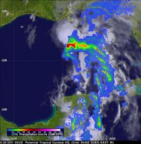
On June 19, 2017 at 1:11 p.m. EDT (17:11 UTC) GPM passed above the Gulf of Mexico. GPM's Microwave Imager (GMI) and Dual-Frequency Precipitation Radar (DPR) instruments showed that the forming tropical cyclone was dumping heavy rainfall in an area from the center of the Gulf of Mexico into the north-western Caribbean. DPR data indicated that a line of powerful convective storms was dropping rain at a rate of over 10.4 inches (265 mm) per hour in the Yucatan Channel between Mexico and Cuba.
Read more at NASA/Goddard Space Flight Center
Image: On June 20 at 2:21 a.m. EDT (0631 UTC), GPM showed that the potential tropical cyclone was producing bands of rainfall over much of the eastern Gulf of Mexico. Rainfall was measured in some of these intense rain bands falling at a rate of over 8.7 inches (220 mm) per hour. (Credit: NASA/JAXA, Hal Pierce)


