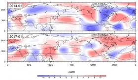
The crippling wintertime droughts that struck California from 2013 to 2015, as well as this year's unusually wet California winter, appear to be associated with the same phenomenon: a distinctive wave pattern that emerges in the upper atmosphere and circles the globe.
Scientists at the National Center for Atmospheric Research (NCAR) found in a recent study that the persistent high-pressure ridge off the west coast of North America that blocked storms from coming onshore during the winters of 2013-14 and 2014-15 was associated with the wave pattern, which they call wavenumber-5. Follow-up work showed that wavenumber-5 emerged again this winter but with its high- and low-pressure features in a different position, allowing drenching storms from the Pacific to make landfall.
"This wave pattern is a global dynamic system that sometimes makes droughts or floods in California more likely to occur," said NCAR scientist Haiyan Teng, lead author of the California paper. "As we learn more, this may eventually open a new window to long-term predictability."
Read more at National Center for Atmospheric Research / University Corporation for Atmospheric Research
Image: The high- and low-pressure regions of wavenumber-5 set up in different locations during January 2014, when California was enduring a drought, and January 2017, when it was facing floods. The location of the high and low pressure regions (characterized by anticylonic vs. cyclonic upper-level air flow) can act to either suppress or enhance precipitation and storms. The black curves illustrate the jet streams that trap and focus wavenumber-5. (Image by Haiyan Teng and Grant Branstator, ©UCAR.)


