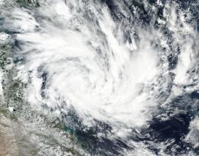
The area of tropical low pressure designated System 91P appears to be organizing in NASA satellite imagery on March 24. Visible imagery from NASA-NOAA's Suomi NPP satellite revealed that the tropical low is consolidating and strengthening in the Coral Sea, South Pacific Ocean.
On March 24, 2017, the Visible Infrared Imaging Radiometer Suite (VIIRS) instrument aboard the NASA-NOAA Suomi NPP satellite captured a visible image of developing System 91P. The image showed bands of thunderstorms spiraling into the low-level center of circulation.
The Australian Bureau of Meteorology (ABM) has posted a Watch Zone for the developing low pressure area that extends from Cape Tribulation to St. Lawrence including Cairns, Townsville, Mackay, and the Whitsunday Islands.
On March 24 at 8 a.m. EST/U.S. (10:00 p.m. AEST/Australia Eastern Standard Time), the ABM said that the tropical low had sustained winds near the center at of 24 knots (28 mph/45 kph). The low pressure area is located near 16.9 degrees South latitude and 151.9 degrees east longitude, about 650 kilometers east of Cairns and 600 kilometers east northeast of Townsville.
Read more at NASA / Goddard Space Flight Center
Image: On March 24, 2017, the VIIRS instrument aboard NASA-NOAA's Suomi NPP satellite captured this visible image of developing System 91P in the Coral Sea. (Credits: NASA / NOAA)


