NASA's Aqua satellite provided an infrared look at Hurricane Maria's cloud top temperatures and found the coldest cloud tops and strongest storms were facing east of the center and away from the U.S. However, Maria is a large hurricane. On Sept. 26, the National Hurricane Center reported that hurricane-force winds extend outward up to 105 miles (165 km) from the center and tropical-storm-force winds extend outward up to 240 miles (390 km).
NASA's Aqua satellite provided an infrared look at Hurricane Maria's cloud top temperatures and found the coldest cloud tops and strongest storms were facing east of the center and away from the U.S. However, Maria is a large hurricane. On Sept. 26, the National Hurricane Center reported that hurricane-force winds extend outward up to 105 miles (165 km) from the center and tropical-storm-force winds extend outward up to 240 miles (390 km).
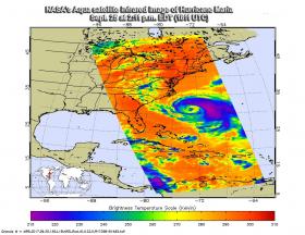
The Atmospheric Infrared Sounder or AIRS instrument aboard NASA's Aqua satellite passed over Hurricane Maria on Sept. 25 at 2:11 p.m. EDT (1811 UTC) and analyzed the storm in infrared light. Infrared light provides scientists with temperature data and that's important when trying to understand how strong storms can be. The higher the cloud tops, the colder and the stronger they are. So infrared light as that gathered by the AIRS instrument can identify the strongest sides of a tropical cyclone. The AIRS image clearly showed the bulk of strong storms in Maria's northeastern quadrant as well as in the storms surrounding the eye.
Read more at NASA/Goddard Space Flight Center
Image: NASA's Aqua satellite provided an infrared picture of Hurricane Maria's cloud top temperatures from Sept. 25 at 2:11 p.m. EDT (1811 UTC).
Credits: NASA JPL, Ed Olsen


