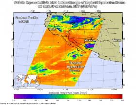
Infrared imagery from NASA's Aqua satellite has revealed that the area of strongest storms within now Tropical Depression Norma has diminished.
Infrared imagery from NASA's Aqua satellite has revealed that the area of strongest storms within now Tropical Depression Norma has diminished.
The Atmospheric Infrared Sounder or AIRS instrument aboard NASA's Aqua satellite analyzed Norma in infrared light. Infrared light provides scientists with temperature data and that's important when trying to understand how strong storms can be. The higher the cloud tops, the colder and the stronger they are. So infrared light as that gathered by the AIRS instrument can identify the strongest sides of a tropical cyclone.
When NASA's Aqua satellite flew over Norma on Sept. 19 at 5:29 a.m. EDT (0929 UTC) the AIRS detected a smaller area of strong storms than the previous day. In that small area cloud top temperatures were as cold as minus 63 degrees Fahrenheit (minus 53 degrees Celsius). Storms with cloud top temperatures that cold have the capability to produce heavy rainfall.
Norma has moved far enough away from coastal areas that all watches and warnings have been dropped.
Read more at NASA/Goddard Space Flight Center
Image: On Sept. 19 at 5:29 a.m. EDT (0929 UTC) the AIRS instrument aboard NASA's Aqua satellite captured this false-colored infrared image of Tropical Depression Norma. Some cloud top temperatures in strong storms were as cold as minus 63 degrees Fahrenheit (minus 53 degrees Celsius). (Credit: NASA JPL, Ed Olsen)


