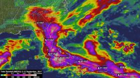
NASA calculated the rainfall left in the wake of now post-tropical cyclone Irma as it moved through the Caribbean Sea to landfall in Florida and then captured a night-time look at the storm as it moved over Georgia.
NASA calculated the rainfall left in the wake of now post-tropical cyclone Irma as it moved through the Caribbean Sea to landfall in Florida and then captured a night-time look at the storm as it moved over Georgia.
NASA found that Irma dropped extremely heavy rain at times during its trek. Starting from near the Cape Verde Islands in the eastern Atlantic Ocean all the way across the Atlantic to the western Atlantic's northern Leeward Islands, Cuba and the southeastern United States.
Over 16 inches (406 mm) of rain was reported in Guantanamo, Cuba in the easternmost province of Cuba, as the category five hurricane battered the country. Almost 16 inches (406 mm) of rain was also reported at Fort Pierce on the eastern side of Florida. Charleston, South Carolina reported 6 inches (152.4 mm) of rain in 24 hours. This heavy rainfall plus storm surge flooding caused the worst flooding in Charleston since hurricane Hugo hit the state in 1989.
Read more at NASA/Goddard Space Flight Center
Image: From Sept. 5-12, 2017, NASA's IMERG calculated heavy rain along Irma's path across the Atlantic Ocean. Rainfall totals were often greater than 6 inches (152.5 mm) around Irma. The greatest IMERG rainfall estimates were indicated by more than 20 inches (512 mm) over Cuba. (Credit: NASA/JAXA, Hal Pierce)


