NASA satellite imagery provided a couple of views of Hurricane Jose's cloud-filled eye allowing forecasters to see that it still existed. NASA-NOAA's Suomi NPP satellite provided a visible look at the storm, while the GPM satellite provided a deeper look under the high clouds that were covering the eye.
NASA satellite imagery provided a couple of views of Hurricane Jose's cloud-filled eye allowing forecasters to see that it still existed. NASA-NOAA's Suomi NPP satellite provided a visible look at the storm, while the GPM satellite provided a deeper look under the high clouds that were covering the eye.
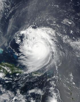
The Visible Infrared Imaging Radiometer Suite (VIIRS) instrument aboard NASA-NOAA's Suomi NPP satellite provided a visible image of Hurricane Jose and showed that the eye had become cloud-filled eye on Sept. 10 at 1:12 p.m. EDT (1712 UTC).
On Sept. 11, the National Hurricane Center (NHC) noted "although Jose's satellite appearance is somewhat degraded due to the effects of northeasterly shear estimated to be near 25 knots it has been able to maintain persistent deep convection over the center."
Read more at NASA/Goddard Space Flight Center
Image: The Visible Infrared Imaging Radiometer Suite (VIIRS) instrument aboard NASA-NOAA's Suomi NPP satellite provided a visible image of Hurricane Jose and its cloud-filled eye on Sept. 10 at 1:12 p.m. EDT (1712 UTC). (Credit: NOAA/NASA Goddard MODIS Rapid Response)


