NASA's fleet of satellites have been continually providing forecasters with data on Hurricane Irma. NASA-NOAA's Suomi NPP satellite provided a look at the wide-eye of Irma and if you think about the area of maximum sustained winds around the eye, it's similar to a wide F2 tornado.
NASA's fleet of satellites have been continually providing forecasters with data on Hurricane Irma. NASA-NOAA's Suomi NPP satellite provided a look at the wide-eye of Irma and if you think about the area of maximum sustained winds around the eye, it's similar to a wide F2 tornado.
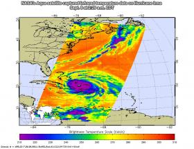
The Atmospheric Infrared Sounder or AIRS instrument aboard NASA's Aqua satellite captured infrared temperature data on Hurricane Irma on Sept. 8 at 2:29 a.m. EDT (0629 UTC). The image showed very cold cloud top temperatures colder than minus 63 degrees Fahrenheit (minus 53 degrees Celsius) in the storm, stretching over Hispaniola, eastern Cuba and the Bahamas. NASA research has shown that cloud tops that cold are high in the troposphere and have the potential to generate heavy rainfall.
Continue reading at NASA / Goddard Space Flight Center
Image: NASA's Aqua satellite captured infrared temperature data on Hurricane Irma on Sept. 8 at 2:29 a.m. EDT (0629 UTC). The image showed very cold cloud top temperatures colder than minus 63 degrees Fahrenheit (minus 53 degrees Celsius) in the storm, stretching over Hispaniola, eastern Cuba and the Bahamas.
Credits: NASA JPL / Ed Olsen


