The Eastern Pacific Ocean's potential tropical cyclone has developed into Tropical Storm Lidia. NASA's Aqua satellite observed some very high, towering thunderstorms in two areas of the storm and because of its close proximity to land, warnings are already in effect for areas in Mexico.
The Eastern Pacific Ocean's potential tropical cyclone has developed into Tropical Storm Lidia. NASA's Aqua satellite observed some very high, towering thunderstorms in two areas of the storm and because of its close proximity to land, warnings are already in effect for areas in Mexico.
Lidia is close to land and has triggered a number of warnings and watches on Aug. 31. The National Hurricane Center (NHC) noted that a Hurricane Watch is in effect for Baja California Sur from Puerto Cortes to east of La Paz, Mexico. A Tropical Storm Warning is in effect for Baja California peninsula from Puerto Abreojos to Mulege and for the Mexico mainland from Bahia Tempehuaya to Bahia Kino. In addition, a Tropical Storm Watch is in effect for Baja California peninsula north of Punta Abreojos to Punta Eugenia, and for the Baja California peninsula north of Mulege to Bahia De Los Angeles as well as mainland Mexico north of Bahia Kino to Puerto Libertad.
Infrared Data on Lidia Shows Strength
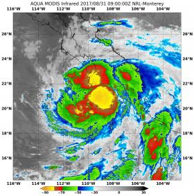
The Moderate Resolution Imaging Spectroradiometer or MODIS instrument that flies aboard NASA's Aqua satellite captured infrared temperature data on Tropical Storm Lidia on Aug. 31 at 5 a.m. EDT (0900 UTC). Infrared data provides temperature information which helps forecasters know where the strongest, highest storms with coldest cloud tops are within a tropical cyclone.
Read more at NASA/Goddard Space Flight Center
Image: NASA's Aqua satellite captured infrared temperature data of newly developed Tropical Storm Lidia on Aug. 31 at 5 a.m. EDT (0900 UTC). Strong storms around the center, and north of the center (yellow) were as cold as minus 80 degrees Fahrenheit (minus 62.2 Celsius). (Credit: NRL/NASA)


