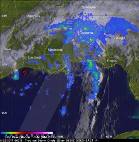
NASA's Aqua satellite analyzed Tropical Storm Cindy in infrared light to identify areas of strongest storms and the Global Precipitation Measurement mission or GPM satellite found locations of heaviest rainfall as Cindy was making landfall along the U.S. Gulf Coast states.
The Atmospheric Infrared Sounder or AIRS instrument aboard NASA's Aqua satellite looked at Tropical Depression Cindy in infrared light. The AIRS image was taken on June 21 at 19:53 UTC (3:53 p.m. EST) and showed some cloud top temperatures of thunderstorms near the center of circulation as cold as minus 63 degrees Fahrenheit (minus 53 degrees Celsius). NASA research has shown the storms with cloud tops that cold have the potential to generate heavy rainfall.
The infrared data was false-colored at NASA's Jet Propulsion Laboratory in Pasadena, California, where AIRS data is managed.
Cindy made landfall around 3 a.m. CDT in southwestern Louisiana. At that time, the National Hurricane Center or NHC said that Cindy was centered about 30 miles (45 km) west-southwest of Lake Charles, Louisiana.
Measuring Rainfall Rates from Space
The GPM core observatory satellite passed above as Tropical Storm Cindy was approaching the western Louisiana coast on June 22, 2017 at 2:21 a.m. EDT (0621 UTC). Cindy had maximum sustained winds of about 40 knots (46 mph) at that time. Rainfall derived from Microwave Imager (GMI) and Dual-Frequency Precipitation Radar (DPR) measurements showed that there was very little rainfall near Cindy's center of circulation but bands of moderate to heavy showers were seen moving into the states along the Gulf Coast. GPM's Radar (DPR Ku Band) found that storms over central Alabama were dropping rain at a rate of over 3.6 inches (91 mm) per hour.
Read more at NASA's Goddard Space Flight Center
Image: On June 22 at 2:21 a.m. EDT (0621 UTC) GPM very little rainfall near Cindy's center of circulation but bands of moderate to heavy showers were seen moving into the states along the Gulf Coast. Storms over central Alabama were dropping rain at a rate of over 3.6 inches (91 mm) per hour. (Credits: NASA/JAXA, Hal Pierce)


