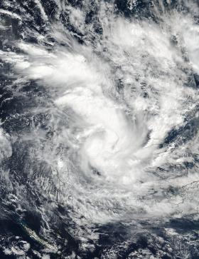
The tropical low pressure area previously known as System 99P organized and developed into tropical cyclone Donna in the South Pacific and now threatens Vanuatu. NASA-NOAA's Suomi NPP satellite provided visible and infrared data on the newly developed storm.
Donna developed into a tropical storm on May 2 at 2100 UTC (5 p.m. EDT) about 484 nautical miles northwest of Suva, Fiji.
On May 3 at 0224 UTC (May 2 at 10:24 p.m. EDT) the Visible Infrared Imaging Radiometer Suite (VIIRS) instrument aboard the NASA-NOAA Suomi NPP satellite captured a visible image of the newly developed tropical storm. The VIIRS image showed strong thunderstorms around the center of circulation and extending to the north in a large thick band.
At 0900 UTC (5 a.m. EDT), Donna's maximum sustained winds had increased to 55 knots (63 mph/102 kph). It was located near 12.7 degrees south latitude and 171.0 degrees east longitude, about 344 nautical miles north-northeast of Port Vila, Vanuatu. Donna has tracked westward at 5 knots (5.7 mph/9.2 kph).
Read more at: NASA / Goddard Space Flight Center
Image: On May 3 at 0224 UTC (May 2 at 10:24 p.m. EDT) the Visible Infrared Imaging Radiometer Suite (VIIRS) instrument aboard the NASA-NOAA Suomi NPP satellite captured a visible image of the newly developed tropical storm Donna. (Credits: NASA / NOAA)


