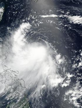
NASA-NOAA's Suomi NPP satellite captured an image of Tropical Storm Nesat being affected by vertical wind shear as it parallels the east coast of the Philippines.
On July 27, 2017 at 12:24 a.m. EDT (0424 UTC) the Visible Infrared Imaging Radiometer Suite (VIIRS) instrument aboard NASA-NOAA's Suomi NPP satellite provided a visible-light image of Tropical Storm Nesat as it continued moving north in the Philippine Sea. The VIIRS image showed thunderstorms circling the low-level center and a band of thunderstorms northwest of the center, running parallel to the coast of the Northern Philippines. The image also showed that the bulk of Nesat's clouds were being pushed to the southwest as a result of northeasterly vertical wind shear.


